Having thoroughly enjoyed helping run the 3rd year Ecologist’s field course in Switzerland at the start of the summer, I’m now getting ready to bookend the summer vacation with something completely different. The other field course destination this year is Belize, in Central America, and we are off there tomorrow. Although Belize’s geological and tectonic history is linked more closely to North than South America, its fauna and flora are more closely related to South; distinctly neotropical in character. Over the years, I’ve spent plenty of time looking at plants in montane environments but my experience in the tropics could best be described as limited, and non-existent as far as the neotropics are concerned; there will be lots to learn!

We’ll be based at the Las Cuevas research station, built in the heart of the Chiquibul Tropical Moist Forest in SW Belize in the early 1990s by the Belizean Forest Department, in collaboration with the UK’s Natural History Museum. The Chiquibul Forest covers 177 000 hectares of the wider Maya Tropical Forest, which is itself the second largest continuous expanse of Tropical Moist Forest in Central and South America, after the Amazon. Central America is a well-known biodiversity hotspot despite, or perhaps because of, millennia of disturbance by tropical hurricanes and the indigenous Maya people and hundreds of years of logging and Tropical Moist Forest is just one of 85 recognised terrestrial ecosystems in Belize.
This is not primary or ‘virgin’ rainforest – long before Europeans arrived in Central America, the Maya had a sophisticated civilization with their own written language, art, architecture, mathematics, calendar and astronomical systems, and were part of an extensive network of trading states. It’s hard to imagine now but Caracol Archaeological Reserve, which sits within the Chiquibul Forest, was a city with a population of some 120 000 people in the Mayan Classical period, from 250 AD, when the city and its surroundings are thought to have covered an area of 65 square miles. Instead of forest, the land would have been given over to large scale agriculture and construction.
Mayan cities throughout Central America went into decline from around the ninth Century AD, probably because of long periods of drought according to a new study involving colleagues from Earth Sciences at Durham. As a result, much of lowland Belize was again covered in forest by the time the first Spanish colonists appeared in the 16th Century and both the Spanish and the British, who followed shortly afterwards, exploited the forests for valuable hardwood timber, such as mahogany (Swietenia macrophylla) and Spanish cedar (Cedrela odorata). The area north of Belize City became the Crown colony of British Honduras in 1862 and remained under a degree of British rule until 1981, when it finally gained full independence.
Belize currently has a total population of around 440 000 people, a quarter of whom live in Belize City. Elsewhere, the population density is the lowest in Central America, though increasing. Unsurprisingly, this is linked to increases in both intensive and traditional slash and burn deforestation for agriculture and, although in theory a quarter of the country’s land is protected, this is not aways the reality on the ground. The Chiquibul Forest is the largest protected area in Belize but part of it (the Chiquibul Forest Reserve) is still managed for timber production under a government license. There was a 15% decrease in primary humid forest in Belize between 2002 and 2024 and the building of dams and flooding of land for hydroelectric power is compounding the problem. What makes Las Cuevas so important is that a 100 hectare area around the station is completely protected and earmarked for research into how the region can develop sustainably, balancing development with conservation needs, its aims being, ‘To document and make known the biodiversity of the Maya Forest, and contribute practical knowledge to the sustainable development and conservation of the Chiquibul-Maya Mountains Key Biodiversity Area’.

Much of the Chiquibul Forest is underlain by metamorphosed mudstones and shales which produce poor, acidic soils. However patches of limestone, laid down when Belize was under the sea, overly this in places in the western Chiquibul, giving rise to the Karst scenery which gives Las Cuevas its name and provides its water supply. The station lies close to the mouth of a large cave, by the Monkey Tail River, 550 m above sea level in the Maya mountains. Nutrient-rich, limestone-derived soils which build up in depressions in the karstic landscape are good at collecting and retaining water during the wet season and so can act as refugia for species during periods of extended drought and during forest fires. By promoting and maintaining forest diversity around Las Cuevas, these soils also provide resilience to the broader ecosystem, of which they form a key part.
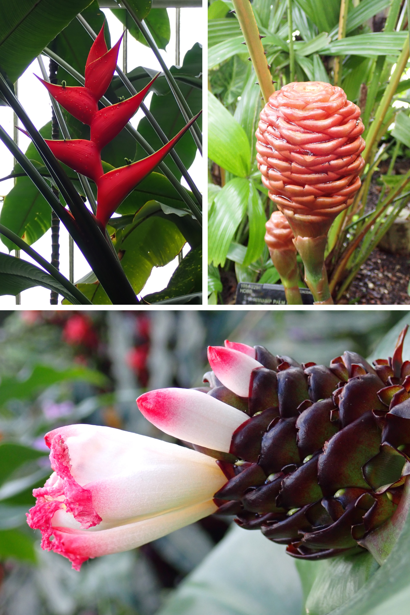
The Belize Ecosystem Map, produced by Meerman and Sabido and last updated in 2017, uses the UNESCO system to classify vegetation, based on physical structure, seasonality, leaf form, altitude, topography, soil type and species composition. It includes ten broad types of forest in Belize, which are then differentiated into many more specific categories. The Chiquibul forest includes the highly-specific and localized “tropical evergreen seasonal broad-leaf forest on steep karstic hills” (BERDS – Spatial Data Warehouse). I’m looking forward to seeing iconic canopy species such as Mahogony (Sweitenia macrophylla), as well as some of the climbers such as Swiss Cheese plants (Monstera sp.) and Strangler Figs, which use the tallest trees to hitch-hike their way up to the canopy. And the epiphytes too – especially the Myrmecodia species which form fascinating partnerships with ants.
Some idea of the biodiversity of Belize can be given by the vast number of known species – 3408 vascular plant species are listed for the country, of which well over 3000 are Angiosperms or flowering plants, from more than 100 plant families). There are more than 450 Angiosperm plant families globally, according to the latest estimates but in the UK, for example, the vast majority of our 2500 plant species are from just 20 plant families. There are also many nonvascular plants and lichens in Belize, but these are less well studied and may be difficult for us to identify. Some of Belize’s angiosperm diversity comes from plant families such as the Lauraceae (laurels), Piperaceae (peppers) and Fabaceae (peas) which appeared more than 66 Million Years Ago (MYA), before the start of the Paleogene period, but more recently evolved families such as the Musaceae (bananas), Zingiberaceae (gingers) Heliconiaceae (heliconias) and Costaceae (spiral gingers) are also important forest understory plants. The nearest I’ve been to most of these plants is at Kew gardens!
Why does the region have such floral biodiversity? There are several contributing factors. One is that, after the supercontinent Gondwana started to break apart some 180 MYA, there were multiple migrations of plants over land bridges and through areas at higher latitudes (such as the southern half of the UK) which were much warmer 50 MYA than they are today. Some families however, such as the Fabaceae, are now thought likely to have arrived by long distance dispersal events such as seeds being carried across oceans. The origins of the region’s faunal biodiversity are much later, in geological terms. A mere three MYA a land bridge was finally completed, linking together the volcanic islands between the continents of N and S America to form the Isthmus of Panama. This allowed animals to migrate in both directions in a process known as the Great American Interchange. Some species, such as anteaters, sloths, opossums and armadillos originally came to Belize from S America, whilst others, such as jaguars and pumas originated in N America.
Equally, there are conflicting theories about how the tropics have maintained this biodiversity – species richness is nearly almost highest near the Equator. Suggestions include: that these areas may have been less vulnerable to extinction events during recent glacial periods; that the heterogeneity of tropical forest environments means that more species can coexist, because of niche differentiation, and that regular large scale disturbances caused by hurricanes, combined with a low density of understory plants maintained by high herbivory rates, means that different species are likely to get lucky each time a gap is created in the canopy. There are also the suggestions that environments with less pronounced seasonality favour species with smaller ranges and less ecological tolerance, leading to greater heterogeneity, or that high levels of environmental energy (from the sun) support greater biomass and increased rates of evolution due to higher metabolic rates, shorter generation times and higher mutation rates. So many possibilities, and very likely a range of factors contribute!
So what am I most looking forward to seeing apart from plants? Scarlet Macaws are high on the list, as I’m currently reading Bruce Barcott’s book ‘The Last Flight of the Scarlet Macaw’ about Sharon Matola’s fight to save a valuable part of the iconic bird’s habitat, devastated by the building of the Chalillo Dam. And who wouldn’t want to see a tiny, brightly coloured tree frog or a beautiful butterfly or moth. I’m less sure about the snakes and spiders…..
